Finishing the National Parks Tour---Completed
September 6-11, 2012
After getting many park stamps in my passport book during my last two adventures, it's now time to complete the project by going to Maine and getting more stamps along the way. On the way home, I'll stop in Washington, DC to spend a few nights with my daughter Rachel.
I'll try to update this blog as I go.
Well, I'm home and the bike is safely in the garaage.
All in all, this was a great trip, even with the slight mechanical problem I had near Cleveland. I was able to avoid riding at night except for about an hour, and I had zero inches of rain. As in all IronButt rides, I was able to see parts of our country that I would not ordinarily see.
My greatest lasting impression is of the 'oldness' and general decay of some parts of the major cities of the old industrial midwest and to a lesser extent in the northeast.
In Cincinnati, Cleveland, and Buffalo I rode through large areas of abandoned factories and warehouses. In Buffalo, some of these were near the waterfront; areas where the views and ambiance should be able to afford major high rise condos. In Boston there were large areas of similar run-down or abandoned multistory factories that will probably never be used again.
The roads in New England are poor compared to the roads in the south and west. But in New England, there are many vibrant little towns that seem to maintain their decades old charm and character. In the south and west, most of these small towns are slowly shrinking as people move in to the larger cities.
Oh well, thanks for following along. My next trip will be to ????--I don't know when.
Tomorrow I'll leave early and head home for dinner. I won't forget to turn on my SPOT.
I didn't write an entry last night because I stayed with my fellow biker and friend, Bob Collin and his wife, Sharon. So I'll try to catch up now.


Wednesday night, September 12, 2012
Well, I'm home and the bike is safely in the garaage.
 |
| 3,500 miles of bugs |
My greatest lasting impression is of the 'oldness' and general decay of some parts of the major cities of the old industrial midwest and to a lesser extent in the northeast.
In Cincinnati, Cleveland, and Buffalo I rode through large areas of abandoned factories and warehouses. In Buffalo, some of these were near the waterfront; areas where the views and ambiance should be able to afford major high rise condos. In Boston there were large areas of similar run-down or abandoned multistory factories that will probably never be used again.
The roads in New England are poor compared to the roads in the south and west. But in New England, there are many vibrant little towns that seem to maintain their decades old charm and character. In the south and west, most of these small towns are slowly shrinking as people move in to the larger cities.
Oh well, thanks for following along. My next trip will be to ????--I don't know when.
Monday afternoon, September 10, 2012
 |
| Washington Monument |
 |
| WW II Memorial |
I spent today riding and walking around Washington and Northern Virginia collecting stamps and just sightseeing. I didn't have the SPOT with me--I left it in Rachel's apartment. I started to take a bunch of pictures, but Washington is pictured out--you can see wonderful pictures of this city almost anywhere you look. Tonight we'll have a leisurely dinner.
Sunday night, September 9, 2012
 | ||
| Two more bikes are hidden in Bob's garage |
I didn't write an entry last night because I stayed with my fellow biker and friend, Bob Collin and his wife, Sharon. So I'll try to catch up now.
Yesterday, I left the hotel early to get to the Marsh-Billings-Rockefeller Mansion in Woodstock, Vermont. The hour ride was on two lane roads, with a constant double yellow line. This would not have been a fun ride to take at night. Another not-fun aspect of riding these roads at night are the road signs, like this one.

The mansion was supposed to open at 10 am, but I got there early and the ranger was nice enough to open the door so I could get my stamp.
Then on to Cornish, Vermont, about 40 miles f two lane no passing road to get the stamp at the Saint-Gaudens Home. This is the only National Park Service facility in the State.

From there it was a long ride to Bar Harbor, Maine, to visit Acadia National Park. This was a 350 mile ride, mostly interstate, mostly dull and boring. This stamp from Maine was the last 'hard' stamp to get. Now I had all four corners of the US--Alaska, California, Florida and Maine.

While in Bar Harbor, I did what the Mainers or Mainists or Mainiacs (whatever Maine residents call themselves) do and had a nice snack.
 |
| Bob Collin |
As I started towards Boston, the wind on the interstate got stronger, and it certainly looked like rain. That's when I called Bob who was nice enough to invite me for the night.
Bob and Sharon are both retired but both serve as Red Cross volunteers. Each of them has spent as much as a month away from home at disaster sights. Bob is a mental health counselor and Sharon has perform many administrative and executive task at these sights. These are really selfless people.
This morning I left Bob's house and rode to Saugus, MA, to visit the Saugus Iron Works, then on to Danbury, CT, for Weir Farm. When I arrived at Weir Farm. The park range told me that the visitor center was closed today but that the farm itself was open for tours. When I told him that I needed the stamp, he opened the visitor center for me to get the stamp.
 |
| Morristown Visitor Center |
Then s short ride to Morristown, NJ, to visit the Morristown Battlefield. This is tghe first time that I successfully made it from CT to NJ without getting lost on the many NY expressways. I needed gas along the way and paid $4.07 per gallon--it must be really good gas that they sell in NJ.
I then rode to Philadelphia for the Liberty Bell Historic site. I tried to take some pictures here, but my battery was discharged and the camera wouldn't work. Oh well!
Then on to Washington, DC, for dinner with my daughter, Rachel, with whom I staying. Tomorrow I'll be off to visit several sites in the DC area and collect the rest of my stamps.
Friday night, September 7, 2012
First, a few additions and corrections to yesterday’s blog.
I didn’t visit the Theodore Roosevelt Memorial is Cincinnati; it was the
Taft Memorial (correction made).
Second, I didn’t tell you that for about 100 miles
yesterday, my ABS (antilock brake system) warning light was on, indicating
some error in that system. I called
David Lewis at Yamaha of Millington, who is very knowledeable about FJR’s,
and he thought that maybe there was some dirt on the sensors. In any event, the brakes worked fine.
Now for today.
Within five miles of leaving the hotel, the ABS warning
light came on. No big deal, right? But yesterday I was able to get the light to
turn off by shutting the bike off, thereby resetting the system, and
restarting. So I tired that.
To my surprise, the bike wouldn’t start. I was parked on the interstate near a
ramp. The voltmeter was reading 10.0
volts—way low. I waved down a car
getting off the interstate and SHE helped me push the bike to get it
started. I got back on the interstate,
and noted that the voltage was going up m(the battery was charging, so I went
for about ten miles, got off at a gas station, and with the bike still
running, called Gary at the dealership in Millington, who suggested that the
ABS solenoid might be stick open, causing a large drain. So I disassembled part of the bike to get to
the fuse box, and pulled the fuse for the ABS system.
When I cranked the bike again, the voltage started to
increase, so maybe this was the voltage problem.
Off I went on the interstate.
But after about ten minutes, the voltage started to drop. I was getting near Cleveland, so I continued to the James Garfield
Memorial, got my stamp, and called David again.
The voltage was intermittent, going up for a while, and dropping fast. This suggested a charging system failure,
rather than some battery drain. I asked
him to find me a local dealer who could diagnose and fix the problem.
North Ridge Yamaha was 20 miles away in Geneva, Ohio. David called Brian at that dealership, told
him of my problem, and off I went to that dealership. I noted again that the voltage was seem to
get normal, and then drop fast, like the charging system was going off line.

When I got to the dealership, they were waiting for me. At first I was skeptical—the facility had
gravel driveways and looked very old—just a cinderblock building with few
windows. But looks are deceiving.

Dustin put the bike on a lift, I explained the problem, and
off he went working on the bike. He
absolutely knew what he was doing. He
removed the voltage regulator, noted that one of the terminals was full of
burnt plastic from the connector, cleaned everything up, put on a new
connector, checked out the charging system while the bike was on the lift, and
put the whole thing back together. Brian
had removed a new voltage regulator from another new bike, being willing to put
that one on my bike if my regulator was bad.
All in all, these guys were great!
I was back on the road, five hours behind schedule.

A quick trip to Cleveland to the Roosevelt Memorial--it had to be quick because I would be near their closing time. I made it with about five minutes to spare.
I rode the next 300 miles on interstate 90—the NY Thruway,
with some speed, and without stopping.
It got dark, and the last forty miles or so was on a two lane road
through the mountains of New York—not
a comfortable ride. I got to the hotel
near Lake George, NY, and
10:00 PM. This was about an hour
short of my intended destination, but the next hour would have been more night
riding through the mountains, and the next stamp location didn’t open till 10
am, so I decided to stop early.
However, as I was getting on the bike to go to my parking
spot, several [people were eyeing the bike.
They are bikers from Canada. We started about long distance riding and the
Iron Butt Association, and an hour later, I started the bike to park it.
Thursday night September 6, 2012
I planned to leave at 6 am, setting my alarm clock for 4:30. Of course, I didn't need the alar,m, since I woke up at 3 am. After my normal morning rituals, I left the house at 5:30, still very dark.
 |
| Mammoth Visitor Center |
This park is like many of the others I've seen, except there were countless groups of deer along the roadway. The didn't seem to be bothered with me driving near them (thank goodness!).
I drove to the interstate by riding the length of the park to Cave City, KY, got gas and headed north to the Abe Lincoln Birth[place in Hodgenville.

From there I went to Cincinnati to the Theodore Roosevelt Home, which is located in a horrible poor part of the city. Driving through this part of town was very depressing. I absolutely would not want to go here at night--in fact, the Roosevelt site was surround.ed by a large wrought iron fence.
From there I took the interstate to Dayton to get some stamps from the Wright Heritage sites surrounding the city. While there, I spent an enjoyable hour or so with Mike Hoegler who will be riding in 2013 IBR. The temps in Ohio hovered around 90 degrees and very sunny--it was very hot.
From Dayton I headed towards Cleveland to get to the Garfield Historic site. I stopped for the night in Medina, about an hour away. The site doesn't open till 10 am, so being an hour away won't hurt my schedule.
Heaven to Hell 1000 Ride ----Completed
August 22-23, 2012
Top of Pikes Peak  via
 Independence Pass and Ely, NV to Bad Water in Death Valley - lowest point in
 North America in 24 Hours

This ride was first finished in 2010 by Mike Kneebone, the
founder and president of the modern-day Iron Butt Association, and his son,
Kevin Masa. Some IBA riders may look down
their noses at Saddle sore 1000 mile rides, thinking that ONLY 1,000 miles in a
day in too easy. Well, although the
timing of this ride was not a problem, the roads and road conditions certainly
were a challenge.
When the ride was first conceived, the final portion of the Pikes Peak Highway was unpaved hard packed dirt. It is now paved. But that small difference made little impact on the difficulty of this ride.
The ride starts at the Visitor
Center at the top of Pikes Peak,
travels down the 20 mile Pikes
Peak Highway, through the high plains towards
Buena Vista, then over Independence
Pass and into Äspen. From there the we go to Glenwood Springs,
and pick up Interstate 70 to Salina,
CO, where we join US 50, known
as the loneliest road in the world, since most of it is through the high
desert.
At Ely, NV,
we head south to Beatty, NV, and then down down down to Badwater,
CA, the lowest point in the US.
There were two reasons for me to take this ride, along with
Tim Masterson and Joe Green. First and
foremost, it sounds like a neat ride.
Second, I wanted to collect National Park Service Passport Stamps from Colorado, Nevada and California. (We couldn’t get a stamp in Utah because of the timing and route of this
trip.) One serious negative about the
route is that you could end up riding through the desert on US 50 at
night. There would be no protection from
coyotes and other animals crossing the roadway in the pitch-black
darkness. And hitting one of those
critters would really ruin the day.
So we decided to start our trek from Pike’s
Peak at 3 PM. That time
would take us through Independence
Pass and to Glenwood
Springs during daylight, and put us on the Interstate just at darkness. We would then ride the Interstate until it
ended in US 50, spend 5 hours in a motel, and begin riding again at
daybreak.
The downside of this route and timing is that it would put
us at our destination around 2 PM—the hottest part of the day in one of the
hottest places on the continent. Oh
well, we chose safety over comfort and decided to go with the 3 PM departure
time.
 |
| Joe Green, Howard Entman, Tim Masterson |
We arrived at the Visitors
Center early, about 1:30
PM, parked our bikes, and got off.
Wow! After just three steps I
found myself breathing rapidly—the 14,110 foot altitude makes a difference.
So I decided not to run, just walk slowly to the water
fountain for a nice drink.

I noticed a big sign indicating that this weekend was the
Pikes Peak Ascent and Marathon, where runners
run up the mountain from the base, a running distance of 13.3 miles on dirt
trails, climbing about 8,000 feet while they do it. I like to participate in running events, but
that one’s not on my bucket list!
At 2:56 pm I bought a donut, got my starting cash register
receipt with the time and date, and walked, slowly, back to the bike for the
start.

The ride down was slow.
The road is twisty-turny, and has a double yellow line most of the 20
miles. Most cars drive slower than
motorcycles, so even in low gear, I was riding the brake for a lot of the
way. Some 40 minutes after the start, we
arrived at the base and were able to pick up some speed.
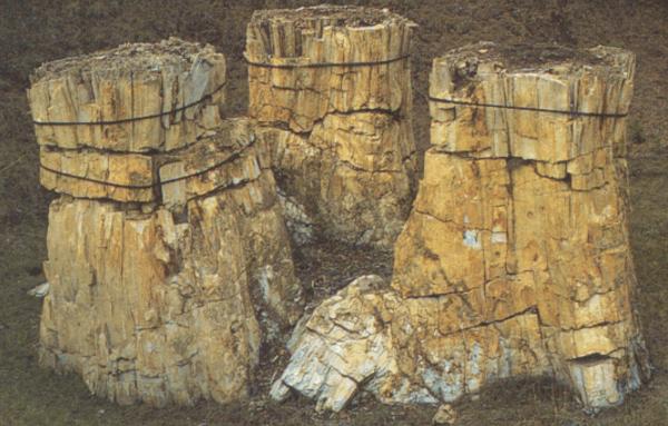 |
| Petrified redwood stumps |
Thirty miles or so from the base, we took a quick detour to Florissant Fossil Beds
National Monument for a
passport stamp. The traffic was very
heavy coming towards us, but just moderate in our direction. The road is two lane, with long stretches of
double yellow lines, so our speed was less than I had planned, but we all had
large fuel tanks, so we didn’t have to stop often.
 |
| Narrow roads in the mountains |
After getting to Highway 82 just north of Buena Vista, we began the
ascent to Independence
Pass. The two lane road has several switchbacks and
many small sections of “narrow road.”
The narrow portions, all running along the side of the mountain, are
clearly not two lane roads. There is no
centerline. It is just a wide single lane. That’s why vehicles are limited to thirty
feet in length for this road.
Fortunately, we didn’t have any oncoming traffic on these narrow
portions.

As we descended from Independence
Pass, we entered the town of Aspen. It was around 7 PM, and the smell of garlic
from the many restaurants in town perfumed the air (and made me hungry). But we were about 30 minutes behind schedule,
so stopping for a nice bistro dinner was out of the question. Besides, Iron Butt riders rarely stop for a
restaurant dinner when on the road.
From Aspen
to Glenwood Springs the road became four lane, faster, but not as pretty. We fueled up at Glenwood and got on the
interstate just as it was getting dark.
The three hour, 250 mile ride on the interstate to Salina was
uneventful. Even on the interstate, you
must maintain awareness of what’s on the road ahead. There were no animals, but there were three
truck tire carcasses in the middle of the road on this stretch. Running over one of those could damage the
bike and the rider.
We had made reservations in Delta, UT, for the night. That was a one hour ride from Salina—again, a two lane
road, reasonably flat, but with no fencing on the sides to keep the animals
away. Even with my bright high intensity
headlights, I felt like I couldn’t see far enough down the road or to the
sides. On this stretch I saw one deer
along the side of the road and a larger brown animal, maybe a moose, in a field
about 100 feet from the road.
We checked in to the hotel, fell immediately to sleep, awoke
4 hours later without the benefit of an alarm, and ate a quick motel
breakfast. Then we were off, riding down
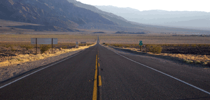
US 50 in the early morning sun.
 |
| Highway 50 |
The stretch to Ely is about 100 miles, and there were only a
few little towns along the way.
Otherwise, there was nothing but desert.
No cell phone coverage, few if any cars going the other way, and a speed
limit of 70 mph. Tim led this leg and
our speed was right at the speed limit.
Just after we passed the sign "Ëly City Limit,” there was a
large gas station, but Tim passed it and continued into and through town; he
also passed the intersection with Highway 93 where we needed to turn left.
Several blocks farther, Tim did turn left and we stopped at a
smaller gas station, where we fueled. He
had put this gas station in his GPS some time ago when we talked about spending
the night in Ely. In any event, it took
15 minutes or so to find our way back to the highway—we had a grand tour of Ely
as our GPS kept trying to take us onto unpaved hilly streets in town. At this point, I pulled into the lead and
picked up the pace just a little.
The road to Beatty was much like the road to Ely—barren
desert with a town every 50 miles or so.
The rawness of the landscape was beautiful!
The temperature in Ely was pleasant, but the closer we got
to Beatty, the warmer -- no hotter-- it got.
Three miles before Beatty there was road construction
narrowing the road to one lane with a sign that said “Expect long
delays—possibly 30 minutes.” This is NOT
what any rider on a timed run wants to see.
Fortunately, our side of the road was moving slowly when we arrived—we
didn’t have to wait at all. The single
lane stretch was about 5 miles long and took 15 minutes to cover. Had we arrived 5 minutes later, we might have
been stuck there while the cars from the other direction made their way.
Sitting on your bike in full riding gear, in the sun, in the
desert, would not make for a fun experience!
At this point, we knew that we would meet our time objective
at Badwater, which was some 45 minutes away.
Tim and I took off our shirts and soaked them in the sink at the gas
station. This would keep us cooler for
the ride into Death Valley. Joe decided not to do this. And off we went.
 |
| Highway 190 in Death Valley |
 |
| Note the air temp |
The paved roads in Death Valley
are excellent. The speed limit in the
park is 45 mph, but everybody travels a little faster. On the way, we stopped at the park’s visitor
center in Furnace Creek for our stamp.
We didn’t stay here long, because the temperature was 113 degrees!

Fifteen minutes later, we arrived at Badwater. We made it!
 |
| Self portrait |
The trip, including our rest stop, took a little more than 23
hours—essentially what we had planned.
There were no íncidents along the way.
All in all—a great trip!
Key West, FL - Prudhoe Bay, AK
June 1-July 11, 2012---Completed

This ride is hosted by the Motorcycle Tourers Forum (http://www.mctourer.com/) in conjunction with the Iron Butt Association (http://ironbutt.com/ridecerts/getdocument.cfm?DocID=22). The goal is to ride from Key West to Prudhoe Bay, about 5,500 miles, in 30 days or less. This isn't a fast pace, but the distance is great, and the road conditions vary considerably, from the U.S. interstates, to the Canadian backroads, to the Dalton Highway, which contains 300 or so miles of packed gravel.
Twenty five people have signed up for the ride, but each of us will be riding our own ride to Fairbanks, roughly 5,000 miles , where we will meet for dinner on June 15 before starting out on the last 500 miles of the ride. We will not be riding as a group, and most of us will be taking our own unique routes to get to Fairbanks.
As it turns out, I will be riding with three of my friends, Bradshaw Smythe, Joe Green, and Duncan Ragsdale as a group. (Brad, Duncan and I live in Memphis; Joe lives in Central Florida). I've ridden with each of the three others (although they have not ridden with each other) and am confident that we will be compatible in both riding ability, endurance, and good humor.
As we progress, I'll try to post some comments and pictures here for your vicarious pleasure. I will be wearing a satellite transponder that records my position on a map every ten minutes or so.
You can also follow our progress on our spotwalla site (Our current position).
You can also see the current location of some of the other riders by going to this page (Other riders).
The Prelude
 |
| Our route to St. Augustine |
First we have to get from Memphis to Key West for the official start of this event.
Duncan, Brad, and I will leave Memphis on May 31. Brad and I will spend the night in St. Augustine, and Duncan will continue farther until he stops for the night. He has a sailboat that is docked in Key West and wants to spend a few hours dealing with some boat issues before we leave on June 2. The ride to St. Augustine should be roughly 12 hours, so if we get out of Memphis by 7 AM CDT, we should get to St. Augustine by 8 PM EDT. Brad and I will meet up with Joe somewhere along I-95 going to Key West on June 1 and arrive there in the early evening.
First Day-May 30
 |
| Howard, Brad and Duncan getting ready to leave Memphis |
The day started out with just a few minor glitches--mostly in communications stuff--that persisted for most of the day. There were no mechanical issues. We had very heavy rain and winds around Valdosta, GA, so we drove into a rest stop--actually I did drive into the building--to stay out of the wind and rain. After a 45 minute wait, we left in gentle rain that lasted, on and off, until Jacksonville.
I have some meeting tomorrow morning at our new townhouse, and after those, maybe 10 AM, Brad and I will head to Key West. Duncan decided to go a little further tonite so that he can get to Key West earlier.
Second Day-June 1
This morning was damp and gray. But that was the best weather of the enire day!
After meeting with a few folks at our new townhouse in St. Augustine, we headed south towards Key West . And it started to rain. First it was a gentle rain, then a hard rain, then a torrential rain. And it kept on raining and raining until we got to Key West.
But we made it-- a little wet but otherwise safe and sound.
Tomorrow we start the trip north. More pictures then.
Third Day--June 2-Key West to Albany, GA
 |
| Joe Green |
This was the first "official" day of the Iron Butt/MTF event. Part of the documentation of the IBA ride involves having a reliable witness attest to your bike's odometer reading at the start and end of the ride. So after a light breakfast we headed down the street in Key West to the local fire station to get a fireman to sign our witness forms. Joe Green is a retired fireman.

We were then going to the "Southernmost point in the US" marker, but decided to get gas first. Unfortuantely, Duncan, who is a free spirit, rode off from the ret of us, so we went for gs without him. When we met at the marker, he knew that he would have to get gas while we rode towards Miami, and we would catch up with us later.
 |
| The group at the marker |
When riding in a group like this, it is important to keep moving--if somebody wants to take a sidetrip from the group, that's okay, but it is up to that person to catch up later.
Well, Duncan did catch up within thirty miles or so, but then decided to stop at an auto parats store for a headlight that had burned out the day before. Again, he said he's catch up with us. However----
 |
| Statue at Everglades Nat'l Park |
We decided to visit the Everglades National Park and the Biscayne National Park as part of the National Parks Tour, the object of which is to collect park rubber stamp imprints in a special 'passport' book. Since Duncan doesn't carry on-board communications, we had no way of telling him of this sidetrip, so he continued north, and ended up two hours ahead of us!

The ride north through Florida was uneventful. There was just a light sprinkle of rain, but the distance was about 700 miles. We arrived at the hotel in Albany, Georgia at about 11 PM after a delicious dinner at one of the Iron Butt favorite restaurants.
Fourth Day--June 3--Albany, GA to Memphis
Nothing much to report today, except we had a lovel and liesurely ride through Georgia and Alabama, passing throiugh Cuthbert, AL, with its nice water tower.

However, once we entered Mississippi, the skies opened up and we had torrential rain--so hard that it would be more dangerous to stop along the side than to continue slowly behind a trailer. The rain lasted for about ten miles, but when we reached the clear road again, we were soaked.
Hopefully, the weather will be nicer tomorrow.
Fifth Day-June 4--Memphis-Omaha, NE
Here's the weather this morning. We're going to wait a while before leaving.

 |
| Where's Duncan? |
When we left my house, I called him from the bike, and he said that he had to wait for a phone call from his office, so we passed him, and was going to catch up with us.
To make a long story short, we stopped to get gas, he passed us, he stopped for lunch, we stopped for lunch, we got him on the phone, and he met up in Hardy, AR, alongside the road. But then he left us again.
We decided to stop in Kansas City for the night at 8 PM, but Duncan rode on through the Omaha.
Brad, Joe and I decided at dinner not to go to Omaha, but rather to ride through Nebraska rather than through South Dakota, so Duncan will be riding alone today towards Rapid City, and hopefully the three of us will meet up with him later tomorrow.
 |
| Where's Duncan |
Sixth Day--June 5--Kansas City, Mo-Custer, SD
Nothing to report today. Good roads, good weather, no neat pictures. More interesting stuff tomorrow.
we did meet up with Duncan in Custer, SD where we will spend the night. We also met up with Tim Masterson,
 |
| Tim Masterson |
a fellow Iron Butt Rally finisher who is also going to Alaska to visit Denali Park. He might ride with us to Fairbanks.
Seventh Day--June 6--Custer, SD-Laurel, MT
 |
| Today's route |
We had dinner last night with Tim. He told us he might ride ahead of us to Fairbanks because he had to gegt home sooner than us.
 |
| Brad at Mt. Rushmore |
 |
| Devils Tower |
 |
| Cemetery at Little Bighorn |
Tim did leave us after visiting Little Bighorn.
Eight day--June 7--Laurel, MT to Bonners Ferry, ID

 |
| Nice scenery |
Needless to say, towards the end of the day, it started to rain gently, and it rained all the way to Bonners Ferry.
I stayed at Tyler's house, and the other three stayed at the Log Inn, about ten miles away. Dinner was quite delicious and the company was great. With all the rain, I didn't take any pictures of Tyler or his family.
Ninth day--June 8--Bonners Ferry, ID to Jasper, Alberta
I'll include some pictures later. Today we left in tyhe rain, we rode all day in the rain, and we arrived in the rain. The temp was in the high 30s to low 40s.
This was not a fun day.
Tenth Day--June 9--Early morning
We're in Jasper; just got the weather report for the yukon,yukon road info.
Emergency road closures or advisories:
- Several washouts and mudslides have occurred between Watson Lake and
Teslin, and Haines Junction and Destruction Bay on the Alaska Highway.
Washouts have also occurred between Carcross and Fraser on the South
Klondike Highway. Travel within these regions is not advised at this
time.
- Highway 1, the Alaska Highway, is closed between Jct 37 and Teslin due to a mud slide and washouts.
Highway 1, the Alaska Highway, is closed between Haines junction and Destruction Bay due to a washout near Km 1639.
Late Morning
Wisdom prevails!
We're spending the night here is Jasper, rather than trying to get to Dawson Creek today. The weather certainly can't be worse tomorrow--most likely it will be better.
So we're off for a walk around town in the rain; but that's what frogg toggs are made for.
Eleventh Day,--June 10--Jasper, AB--Dawson Creek, BC
We're off to Dawson Creek after breakfast. Several riders are waiting there for the road to reopen around Watson Lake. The weather here at Jasper has improved, but there is still rain off and on.
 weather early afternoon weather early afternoon |
| early afternoon weather yesterday |
 |
| early evening weather yesterday |
After riding for six hours in a cold (45 degrees) drizzling rain, we arrived in Dawson City and sunshine. The temperature here is in the 70s. It's amazing how fast the weather changes as you go around and across mountain ranges.
 |
| This was the weather most of the day |
 This is the weather in Dawson Creek This is the weather in Dawson Creek |
| This is the weather in Dawson Creek |
Dawson Creek is mile 0 of the Alaska Highway. The highway is still closed due to flooding at mile 665, so until we hear some news about the road being opened, we will probably stay here.
Tim Masterson rode ahead of us and got to the point of road closure. He decided to ride south again to Prince Rupert where he will catch a ferry on Tuesday for the ride to Haines, Alaska which is on the other side of the closure. That ferry only runs on Tuesdays (I think) so we couldn't do that even if we wanted to. The cost for the transit is about $400.
Here are some pictures of the road section that has flooded out causing all this problem


Twelfth Day--Dawson Creek toward St. Rupert
The road closure might be open later this afternoon, but nobody knows for sure, and nobody is saying what the road repair will be--packed dirt, gravel, tree limbs, or whatever. We do know that the traffic will be fierce, with miles of tractor trailers tying to get through. The person we talked with didn't know if the road would be amenable to motorcyles. So....
Five of us were able to get the last reservations for the ferry that goes from St. Rupert, BC, to Haines, AK. This would get us around the boad road section. So we're off in a few minutes to go towards Prince Rupert, probably spending tonite in Smithers, BC.
More from Smithers. By the way, Joe and Duncan did NOT get ferry reservations. Joe will ride to Fort Nelson and wait for the road to open, and Duncan may just head home.
UPDATE
As we traveled through Prince George on our way to Smithers, we saw an information sign that said the road was closed with no detour available. It turns out that thtere was a three car collision 30 miles up the road and the expectation is that the road won't be open until midnite.
Oh well, a slight seven hour delay at the local McDonalds (where there is wi-fi service). We checked in at the no-longer Best Western to get some sleep before reassessing our options.
Days 13, 14 and 15--To Fairbanks
 |
| SS Matanuska |
We got to bed at the no-longer Best Western motel in Prince
George at around 9 PM. We set the alarm
for midnite because we had to confirm and pay for the ferry ride by 1 AM; that
act would depend on whether the road to Prince
Rupert was cleared.
Sure enough, at midnite, we found out that the road was open, so we paid
for the ferry tickets on the internet, and went back to sleep until 3 AM.
The bikes were packed and we were ready to go b y 3:30AM,
went to the gas station down the street, and found them closed. Another gas station was closed also. So we spent 30 minutes looking for an open
station. We didn’t get on the highway
until nearly 4:30 AM.
 |
| camping on the deck |
The ride to Prince
Rupert is 450 miles, and the ferry boarding time is 2
PM. After several delays for construction
along the way, we got to St. Rupert a noon, cleared US Customs at the ferry
terminal, and, eventually, got on the ship.
We got a stateroom (I’m sure glad we did that) even though many people
sleep on the deck outside (cold) or on the floor inside (hard).

Oh, needless to say, it rained for the first half of that
ride. We stopped for breakfast at
Smithers (which was pour destination last night before the road closure) at,
McDonald’s (where else?). We also stopped along the way to take some pictures
at Kleanza Creek Provincial Park as part of our National Parks Tour (Provincial parks
get the same credit as US National Parks).
People who don’t ride motorcycles, and riders who don’t ride
long distances, often ask “Why do you do this? Why ride in the rain? Why deal
with all these inconveniences?” The
answer is as complex as the response to the question “What’s so nice about a
beautiful sunset?” or “What’s so great about a fantastic meal?” But let me try to explain.
When I’m riding my motorcycles, I am part of the
environment. I‘m not in a car looking
straight ahead through a narrow windshield.
I’m not sitting in a climate controlled cabin. I’m not sitting on a sofa-type chair
listening eight channel dolby stereo.
Rather, I can see straight ahead, up to the sky, and fully left to right
without any obstructions. I can smell
the odors surrounding me, from the sweetness of freshly cut grass to the stench
of the feedlots. I do listen to music on
my audio system, but it’s not the same quality as I have in my car.
In short, I’m not a spectator watching the environment go
by; I’m an active participant in the environment. The rain, the bumpy roads, the wind, and the
heat or cold, is just a part of being there.
And since I’m fortunate enough to have several credit cards in my
pocket, if the conditions ever get too bad for my comfort level, I can always
pull over and check into a motel (although I’ve never done that).
Another part of riding is the enjoyment of meeting people
that you would not ordinarily meet, even if you traveled the same route. Bikers are generally sociable people; it’s
real easy to strike up a conversation with a biker-stranger who very quickly
becomes a biker friend.
 |
| Dave Byers |
 |
| Mike Ringler |
 Milen Dimitrov Milen Dimitrov |
| Add caption |
There’s Dave Byers, a bus driver from Ontario, Canada who is riding around the U.S. and Canada on a 56 day trip. And then there’s Mike Ringler and Jim Brown from Palmer,
Alaska, who are coming back from Arizona,
having just bought their motorcycles there.
 |
| Jim Brown |
And Milen Dimitrov, a Bulgarian, who is an electrical inspector and works around
the world, now inspecting pumping stations on the Alaskan pipeline. He lives in Fairbanks and loves it, working two weeks on
and two weeks off. He has been to Prudhoe Bay hundreds of time for his work, and is
planning to ride his Harley up there is next few days. We might get him to join our group.
None of these experienced rides had heard of the Iron Butt Association, but they all asked me to send them some information when I get home.
 |
| Jerry Riley |
Speaking of the group, they did make it across the highway
closure. (Jerry Riley from Eastern Tennessee took the ship also). At this time, they’re in Fairbanks, having arrived here one day before I did. Tim Masterson caught an earlier ferry and
stopped in Juneau
for the night, and got to Haines at 11 AM yesterday, about 14 hours before we
arrived. He will got to Fairbanks Thursday morning; we will got there Thursday evening.
One of the folks we met on the ship asked “Isn’t taking the
ferry ‘cheating’ on the requirements of the ride?” Absolutely not! Part of the challenge of a trip like this is
dealing with the multitude of contingencies and obstacles that arise along the
way. We dealt with the road closure
issue by taking the alternative that gave us the best chance of accomplishing
the objective—getting to Prudhoe Bay. The other rides chose the objective of
waiting and hoping for the road to open, and then going across the fixed
roadway. As it turns out, our ride to the ferry required us to
backtrack our route, so we will end up riding more miles than our friends who
waited for the road to open.
So we’re all winners—our
routes and methods are slightly different, but making these choices is just one of the fun
parts of the whole experience.
Today we had new tires put on our bikes by a highly recommended tire guy, but, perhaps like many people in Alaska, he was a real character. He had no shortage of four letter words, and really didn't inspire much confidence--but--he is highly recommended by people I respect. I don't think that I would back there again.
Tomorrow morning we leave at 4 AM for the ride north. Luckily, the weather looks good, so we're going to try to make the trip and back in one day.
It wouldn't make sense to waste the good weather by spending the night in Deadhorse and waking up to nasty weather for the ride back.
We left the hotel at 4 AM Saturday morning and stated our trek. The first 50 miles or so was decent two lane paved road, but then the road turned to hard park earth with loose gravel for about half mile, then to asphalt for a mile, then back to gravel. This was the routine almost for the entire trip. There were some longer stretches of asphalt, and some ten mile stretches of hard pack road with loose gravel. Non or these roads were really bad, but for those of us who don't ride unpaved roads often, they were challenging.
Alaska does all of its road maintenance in the summer, and since it's light here for the entire 24 hours, road work goes on through the night. Many areas of maintenance were horrible to transit. Some were several mile stretches, lead by a pilot car, where trucks has dumped several inches of pea size gravel just minutes before. Riding a bike through this was no fun.

In fact, about 40 miles before Prudhoe Bay, I lost a battle with a patch of gravel about 6 inches deep. Fortunately (and wisely) I was wearing all sorts of motorcycle protective gear, so I came out fine, and the bike suffered only a cracked windshield. (Today I went to Home Depot and bought a cheap sheet of plastic and made a substitute that I hope will last for the return trip home.
 Prudhoe Bay is nothing. A few hotels, lots of big pick up trucks and one street. But it is the end of the road.
After having a coke at the Prudhoe Bay Hotel, we started back to Fairbanks. The weather was, as predicted, excellent, and the room rates in Prudhoe approach $200 for a bed with bathrooms down the hall. There was no reason to stay.
I'll post more in a day or two.
 We slept well last night in Fairbanks, since we missed a complete sleep cycle the day before. After lots of chatter with the other riders, we finally left the hotel at around noon to go to Dedali Park to get our Parks Tour stamp. The park is 121 miles south of Fairbanks, and getting the stamp meant that we would have to make this side trip out and back to Fairbanks before starting for home.
Mt McKinley was covered in mist, so we didn't see the mountain peak.
The ride from Fairbanks to Tok was uneventful except for--you guessed it--rain.
As I ride through this part of the world, I'm constantly amazed at the vast amounts of timber. There are trees as far as you can see for hundreds of miles of riding. Yet, in the US, small cities have recent unemployment because tghe sawmills have shut down. The locals say that the Environmental Protection Agency (EPA) and Environmental groups like the Sierra Club have made logging almost impossible. Yet, in Canada, small towns seem to prosper harvesting timber. I'll rant on more about this at the end of this travel blog from home.
On to Watson Lake tomorrow. Remember, Watson Lake was the town just east of the road break that caused us to take the ferry on the trip going to Alaska. We'll see how the road was fixed today.
The last two days have been relatively uneventful. We spent last night in Watson Lake, a real nothing hamlet with crummy hotel room and worse food, all of course, over priced.
 On the way from Watson Lake to Fort Nelson, we had some traffic interruptions due to local residents being on the road. Although I could only get a few pictures, we had several incidents of bison and sheep just standing on the road, usually right around a curve. Also. there were literally dozens of bear foraging along side the road.
This would not be a place to ride at night.

Off to Saskatoon tomorrow.
Today was a weird day. Brad and I have been riding togerther for the [past three weeks, and little things that each of us does bothers the other a little--that's natural. This morning we had a two minute talk about these little pecadillos, in a calm voice with no profanity. After my discourse, Brad got on his bike and rode off--he abandoned me in Dawson Creek without saying hardly a word.
This evening I see that he is in Calgary, which was not on our planned route.
When we started this journey, he said that he was taking a full set of tools in case of emergency, and that I didn't have to take a similar set since we would be riding together. Now that he is not with me, I'm somewhat naked in the event of a mechanical breakdown.
Needless to say, we won't be riding together again.
Tomorrow I cross the border into North Dakota and head towards Fargo for the night. If the weather is good on Saturday, I'll make it back to Memphis.
Monday nite--Day 26--Memphis
I'm back in Memphis, awake. I arrived home Saturday nite at 11:55 PM.
I left Saskatoon last Friday morning, and headed towards Regina, then direcly south to Portal, North Dakota.
The highways in this part of Canada are primarily four lane and well maintained. The trip was uneventful. At the border crossing, I was asked the usual questions about firearms, excessive cash, and fruits and vegetables. I admittd that I was carrying an apple that I took from the hotel this morning, and, after examining the apple, the border patrol agent let me keep the apple instead of confiscating it. (Several yeas ago, as we were returning by airplane from Europe, we had an apple in a backpack that was confiscated by customs as we were 'caught' by a Department of Agriculture sniffing dog at Kennedy Airport.) The gas prices in Portal seemed high, so I drove down the road to Lignite, ND, and bought gas there.
 Farther down the road, I stopped in Stanton, ND, to get a NPS stamp at Knife River Indian Village Historic Site. At this point, I was feeling confident that the bike was operating well and that, even without tools, I'd make it back to Memphis.
I rode until 11 PM and spent the night in Watertown, SD.
 Saturday morning I left Watertown with the goal of reaching Memphis, but had to stop in Pipestone, MN, to get a stamp at Pipestone National Monument, about 40 miles off route. Ordinarily, this woouldn't be much of a challenge, but the winds were very strong (around 30 mph), and gusty.
I rode in that wind for about 200 miles and my gas mileage dropped to around 32 mpg, down from 40 mpg that I was getting without the wind.
The rest of the day was just riding riding riding. As it got dark, I started to feel uneasy, since this motorcycle doesn't have headlights that are as bright as my other bike, a Yamaha FJR. Some of the dangers about night riding is hitting an animal crossing the road (yes, even on an interstate) , or running over a tire carcass in the middle of the road. At night, on black asphalt highways, it's hard to see the black tire carcass unless you have very bright lights. So, when it was pitch black (not much of a moon), I waited for a car to pass me and followed that car until I needed gas. The hope is that if the car sees a tire carcass in the road, they would tap their brakes or swerve.
In any event, I didn't run over a carcass.
The bike is now washed and looks half decent. The Home Depot windshield stated to crack about 1,000 miles ago, and even after taping the cracks, the plastic started to bend, so the deflected wind was hitting me int helmet (along with the deflected bugs). Oh well, I guess there's a reason windshields cost more than $10!
I'll change tires and chain in Memphis, and then complete this saga by going back to Key West in the next week or so.


Friday Night--Day 16--Fairbanks
 |
| Tire changing garage |
 |
| The bikes are ready for the trip |
Tomorrow morning we leave at 4 AM for the ride north. Luckily, the weather looks good, so we're going to try to make the trip and back in one day.
 |
| Warms temps and no rain |
It wouldn't make sense to waste the good weather by spending the night in Deadhorse and waking up to nasty weather for the ride back.
Sunday Night--Day 18--Fairbanks
 |
| Caribou near Deadhorse |
 |
| 3 AM photo from our hotel window |
 | ||
| This gal who stops traffic makes $29/hr |
|
| Photo taken at 3AM |
 |
| Roadside park at the Arctic Circle |
In fact, about 40 miles before Prudhoe Bay, I lost a battle with a patch of gravel about 6 inches deep. Fortunately (and wisely) I was wearing all sorts of motorcycle protective gear, so I came out fine, and the bike suffered only a cracked windshield. (Today I went to Home Depot and bought a cheap sheet of plastic and made a substitute that I hope will last for the return trip home.

After having a coke at the Prudhoe Bay Hotel, we started back to Fairbanks. The weather was, as predicted, excellent, and the room rates in Prudhoe approach $200 for a bed with bathrooms down the hall. There was no reason to stay.
I'll post more in a day or two.
Monday Night--Day 19--Tok, AK

Mt McKinley was covered in mist, so we didn't see the mountain peak.
 |
| See the rainbow? |
 |
| Forest all around us |
On to Watson Lake tomorrow. Remember, Watson Lake was the town just east of the road break that caused us to take the ferry on the trip going to Alaska. We'll see how the road was fixed today.
Wednesday night--Day 21--Dawson Creek
The last two days have been relatively uneventful. We spent last night in Watson Lake, a real nothing hamlet with crummy hotel room and worse food, all of course, over priced.

This would not be a place to ride at night.

Off to Saskatoon tomorrow.
Thursday night--Saskatoon
Today was a weird day. Brad and I have been riding togerther for the [past three weeks, and little things that each of us does bothers the other a little--that's natural. This morning we had a two minute talk about these little pecadillos, in a calm voice with no profanity. After my discourse, Brad got on his bike and rode off--he abandoned me in Dawson Creek without saying hardly a word.
This evening I see that he is in Calgary, which was not on our planned route.
When we started this journey, he said that he was taking a full set of tools in case of emergency, and that I didn't have to take a similar set since we would be riding together. Now that he is not with me, I'm somewhat naked in the event of a mechanical breakdown.
Needless to say, we won't be riding together again.
Tomorrow I cross the border into North Dakota and head towards Fargo for the night. If the weather is good on Saturday, I'll make it back to Memphis.
Monday nite--Day 26--Memphis
I'm back in Memphis, awake. I arrived home Saturday nite at 11:55 PM.
I left Saskatoon last Friday morning, and headed towards Regina, then direcly south to Portal, North Dakota.
The highways in this part of Canada are primarily four lane and well maintained. The trip was uneventful. At the border crossing, I was asked the usual questions about firearms, excessive cash, and fruits and vegetables. I admittd that I was carrying an apple that I took from the hotel this morning, and, after examining the apple, the border patrol agent let me keep the apple instead of confiscating it. (Several yeas ago, as we were returning by airplane from Europe, we had an apple in a backpack that was confiscated by customs as we were 'caught' by a Department of Agriculture sniffing dog at Kennedy Airport.) The gas prices in Portal seemed high, so I drove down the road to Lignite, ND, and bought gas there.
I rode until 11 PM and spent the night in Watertown, SD.
I rode in that wind for about 200 miles and my gas mileage dropped to around 32 mpg, down from 40 mpg that I was getting without the wind.
The rest of the day was just riding riding riding. As it got dark, I started to feel uneasy, since this motorcycle doesn't have headlights that are as bright as my other bike, a Yamaha FJR. Some of the dangers about night riding is hitting an animal crossing the road (yes, even on an interstate) , or running over a tire carcass in the middle of the road. At night, on black asphalt highways, it's hard to see the black tire carcass unless you have very bright lights. So, when it was pitch black (not much of a moon), I waited for a car to pass me and followed that car until I needed gas. The hope is that if the car sees a tire carcass in the road, they would tap their brakes or swerve.
In any event, I didn't run over a carcass.
 |
| Home Depot windshield in Memphis |
I'll change tires and chain in Memphis, and then complete this saga by going back to Key West in the next week or so.
Saturday, June 7
I spent the last two weeks at home in Memphis resting, catching up on some house
chores, reading the mail, and doing some maintenance work on the bike. I’m now in Ocala, FL, just 6 short hours from
the finish point of this ride ij Key West (of course I then have to get back to
Memphis).
To bring y’all up to date---
Some riders had some problems on their way home from Alaska. Rob Wilenski, who organized this ride, had
alternator problems in northern Montana,
and couldn’t get parts for the repair for a week, so he elected to rent a
U-Haul trailer and trailer his bike home.
Jeremy Loveall lost his transmission in North Dakota. Jack Backer, a good friend of all long
distance riders, who lives in South
Dakota, rescued Jeremy and put the bile is his
garage. Jeremy’s father shipped him a
rebuilt transmission which Jeremy then installed onto his bike. He then rode home to Kentucky,
and later to Key West
to finish his ride.
Joe Green had a timing belt controller issue that caused him
to stop on the Fl-GA border and trailer his bike home to near Orlando.
He then found a bunch of metal in his transmission fluid, so he is
probably not going to make it to Key
West to finish.
I changed my tires, oil, and chain and sprockets. I know I cold have made it to Key West and back with the
gear I had on the bike, but I’m very cautious about those items.

Today I left Memphis
determined to pick up at least three National Park stamps on my way to Key West. The first stop was at Tupelo National
Battlefield, a national historic site.
Then on to Tuskeegee Airmen’s Museum, another national historic site. Unfortunately, on the way to Montgomery, AL,
interstate 65 was at a dead stop. I
transitioned to Hwy 31, as did everybody else, so the normal hoir and half ride
from Birmingham to Montgomery took almost three hours! I then followed my GPS instructions to the
museum, but those instructions took me through the tiniest streets in
Tuskeegee, and led me to the Park Service office for the museum.

The office, supposedly open until 5 PM was closed before
2PM. After getting directions from
several people, I did find my way to the actual museum, where I got my stamps.
Then on to Plains, GA, for the Jimmy /carter National
Historic site which is in his old high school building. Unfortunately, the site closes at 5 PM, and
with the traffic delay and getting lost
in Tuskeegee, I wasn’t going to make it on time.
 |
| Jimmy Carter Museum |
I arrived there at 5:15, found the door open, and as I walk
in was greeted by a guard. I said
quickly, “Oh, I know you’re closed, but
I just want to get my stamp.”. The guard
relied “Son, this is the south—nothing happens around here on time. Get your stamp and look around if you want
to.”
Which I did.
Then a five hour ride to Ocala, and time for some sleep.
More tomorrow.
Well, This was an exciting and exhausting day. But before I tell all, you must know a little about how a motorcycle chain works.
Almost all replacement chains come in a package like a length of rope--the chain is not continuous like a rubber band. It's necessary to cut the chain to the length you need, loop the chain around the sprockets, and then connect the two chain ends with a gizmo called a 'master link', like the picture.
Simply, you put the two prongs through the two ends, put the plate with the two holes over the prongs, and then place the clip around the prongs ends to keep the plate from falling off. Simple?
As I finished gassing the bike in Pompano, FL, I inspected my tires and chain and saw that the retaining clip on the master link was missing--somehow it had fallen off. When the mechanic put the clip on, he had a real tough time. It shouldn't have been that hard.
If a chain falls off a motorcycle, there is a distinct possibility of a catastrophe, so riding a bike with a bad chain is not a good idea.
I called Greg Rice, an IBA and MTF friend, and the go-to guy in South Florida for any problems. He began calling around to other bikers to see who would have an extra master link (remember, it's Sunday and most motorcycle shops are closed). At the same time, I called Kevin Lechner, president of the MTF, who sent me a list of people nearby who he thought might have some info. Kevin also offered to drive his truck from Melbourne to Pompano if needed.
To make a long story short, one of the riders that Kevin sent me called around and found a master link at Cycle Gear, just eight miles from where I was.
The salesman at Cycle Gear was from England and had ridden chain bikes all his life. He put the clip on the bike in less than a minute, and I was off on the road again.
This entire episode took two hours. I continue to be amazed at the willingness of our group of motorcycle riders to help each other in times like this. From the time of my first call for help, I was receiving help from several bikers, most of whom I haven't met.
 Anyway, now that I was late, it began to rain very very hard, all the way from Pompano to Homestead, about 45 miles. And then, once I was off the turnpike and in the keys, the traffic became very slow. I didn't make it to the destination until 5 PM, about 3 hours later than I thought---but I did make it.
I did make it to Miami for the night, so more tomorrow from somewhere.
I found a store that not only had the master link clips, but also had a chain tool, which I bought to better tighten the master link. After this adjustment, I was in good shape.
From Jacksonville to Memphis, I dodged rain all night. But I wore my frogg toggs, so , although there was rain all around me, I didn't get a single drop on the bike. Amazing!
I considered stopping in Montgomery, AL, or Birmingham for the night, but the weather seemed to be in my favor, and I felt very alert and awake, so I continued home to Memphis, where I arrived at 1:30 AM. That ride from Miami was a bit more than 1,000 miles, and with the stop in St. Augustine, amounted to 20 hours. That's not much for iron butt riding.
So what did I learn from this experience?
Thanks for reading this long saga. If I take another ride like this after they let me out of the mental asylum, I'll let you know.
Sunday night--Miami
Well, This was an exciting and exhausting day. But before I tell all, you must know a little about how a motorcycle chain works.
Almost all replacement chains come in a package like a length of rope--the chain is not continuous like a rubber band. It's necessary to cut the chain to the length you need, loop the chain around the sprockets, and then connect the two chain ends with a gizmo called a 'master link', like the picture.
Simply, you put the two prongs through the two ends, put the plate with the two holes over the prongs, and then place the clip around the prongs ends to keep the plate from falling off. Simple?
 |
| Master Link |
As I finished gassing the bike in Pompano, FL, I inspected my tires and chain and saw that the retaining clip on the master link was missing--somehow it had fallen off. When the mechanic put the clip on, he had a real tough time. It shouldn't have been that hard.
If a chain falls off a motorcycle, there is a distinct possibility of a catastrophe, so riding a bike with a bad chain is not a good idea.
I called Greg Rice, an IBA and MTF friend, and the go-to guy in South Florida for any problems. He began calling around to other bikers to see who would have an extra master link (remember, it's Sunday and most motorcycle shops are closed). At the same time, I called Kevin Lechner, president of the MTF, who sent me a list of people nearby who he thought might have some info. Kevin also offered to drive his truck from Melbourne to Pompano if needed.
To make a long story short, one of the riders that Kevin sent me called around and found a master link at Cycle Gear, just eight miles from where I was.
The salesman at Cycle Gear was from England and had ridden chain bikes all his life. He put the clip on the bike in less than a minute, and I was off on the road again.
This entire episode took two hours. I continue to be amazed at the willingness of our group of motorcycle riders to help each other in times like this. From the time of my first call for help, I was receiving help from several bikers, most of whom I haven't met.

I did make it to Miami for the night, so more tomorrow from somewhere.
Tuesday Night--July 11, 2012
I left Miami and headed towards our newly acquired townhouse near St. Augustine for a look-see after the torrential rains in that area. The ride up interstate 95 was totally uneventful until I reached Daytona, where I noticed that the master link retainer clip was missing again. The backing plate was very secure, though, so I continued to the townhouse, and then called around to Cycle Gear stores in Jacksonville for additional clips.
I found a store that not only had the master link clips, but also had a chain tool, which I bought to better tighten the master link. After this adjustment, I was in good shape.
From Jacksonville to Memphis, I dodged rain all night. But I wore my frogg toggs, so , although there was rain all around me, I didn't get a single drop on the bike. Amazing!
I considered stopping in Montgomery, AL, or Birmingham for the night, but the weather seemed to be in my favor, and I felt very alert and awake, so I continued home to Memphis, where I arrived at 1:30 AM. That ride from Miami was a bit more than 1,000 miles, and with the stop in St. Augustine, amounted to 20 hours. That's not much for iron butt riding.
So what did I learn from this experience?
Thanks for reading this long saga. If I take another ride like this after they let me out of the mental asylum, I'll let you know.